


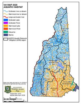
WAP Aquatic Habitats
Aquatic Habitats Data Layer
A detailed Aquatic Habitats data layer was developed in 2015 and updated in 2020. This data layer is a mapped classification of lakes and ponds and rivers and streams based on variables that structure aquatic natural communities. The attributes of the Important Fish Habitat layer were updated in 2020.
How Were the Aquatic Habitats Assessed?
 Surface waters were assessed a little differently than terrestrial habitats. High Quality streams and rivers were classified using an approach developed by The Nature Conservancy based on four attributes. These attributes were applied to each stream reach (section of stream between two confluences of streams). The attributes used were:
- Linear connectivity (length of functional stream network),
- Low riparian development and agriculture,
- No active dams and upstream dam water storage less than 10% of mean annual flow
- Low impervious surfaces (less than 2%) in the watershed
Lakes and Ponds were also assessed for four attributes and applied to the whole pond:
- Local condition (200 meter shoreline buffer): a combination of three factors including percent natural land cover in the buffer, absence of dams, distance to nearest road or trail
- Watershed condition (HUC12): intactness based on percent natural cover
- Index of Ecological Integrity (UMass)
- Size of the water body
What habitats are mapped?
The mapped habitats include five freshwater aquatic habitats described in the New Hampshire Wildlife Action Plan:
- Large Warmwater Rivers
- Warmwater Rivers and Streams
- Coldwater Rivers and Streams
- Warmwater Lakes and Ponds
- Lakes and Ponds with Coldwater Habitat